
I would like to talk to you about Traffic Patterns.
Traffic patterns were developed and are used to ensure safe Air traffic of arriving and departing aircraft to and from an airport ,and are essentially an invisible "sky road" leading to and from a specific runway in a square pattern of turns.
When an Airport (or any kind of airfield) is built, these traffic patterns are created specifically for the runways in that Airport.
-Pilots are required to know and have an airport diagram for the airport they are operating to and from.
-Traffic patterns are Usually Left turning, unless specified otherwise. (i.e. on aerial navigation maps airports with Right patterns are marked with: "RP [runway number]")
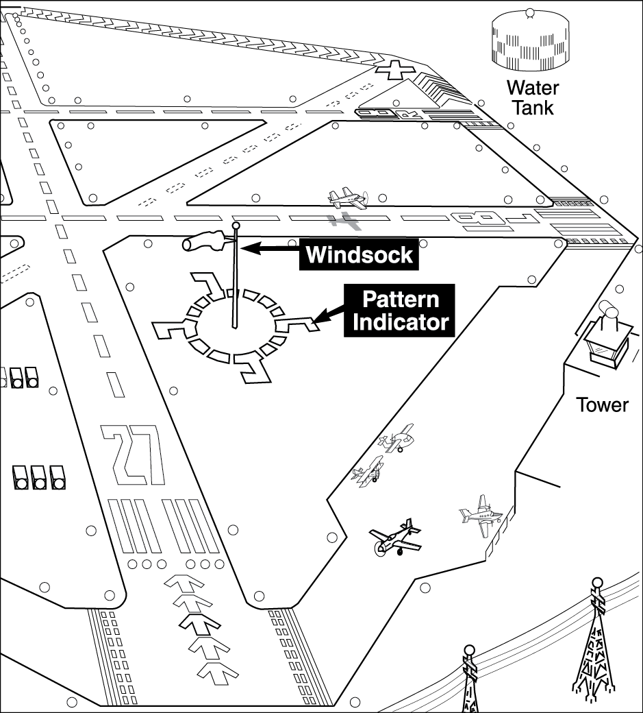
-Traffic pattern direction are marked on some airports around the Wind Stock.
-Traffic patterns also create a funnel to the landing area, allowing aircraft to land in sequence and by numbers referenced by the tower.
The geographical area around the airport, number of Runways, Wind directions and city landscape around airport are all taken into account when creating Traffic patterns for that airport.
I.E. you don't want a traffic pattern that leads into a mountain/building, or over heavily populated areas.
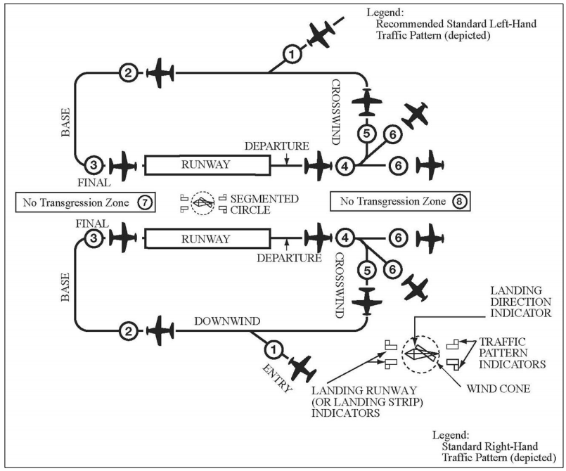
Traffic patterns are broken down to these steps:
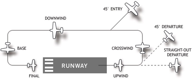
-Upwind - Takeoff (RWY) direction
-Crosswind - 90° turn
-Downwind - 90° turn, abeam to the field about
-Base - 90° turn
-Final - Approach to Landing - 90° turn
-ENTRY - can be made to any part of the pattern at 45° to the direction of the pattern, tho heavy traffic usually dictates an entry to the Downwind part as shown.
(Airport towers will direct pilots on where to join the Pattern according to the traffic around the airport and the pilots heading)
-Traffic Pattern altitude for light/small Airplanes is 1000ft above airport altitude or Above Ground Level (AGL) 200kt or 230mph
-Large and turbine powered airplanes pattern is at 1500ft AGL. (not sure about speed)
-Helicopters Pattern altitude is at 500ft AGL ,75kt , closer to the airport and can be in the other direction to regular Pattern.
(there may be other rules for airships and such but i am not familiar)
Check out my Runway numbers tutorial to learn how to identify which runway you're on.
For Ingame airports i'm gonna use Airfield Chart and Data for reference.
Wright Airport for example
has a bit of a problem with a Left traffic pattern from runway 36 because there's a mountain in the way...

so you take off to a Right Pattern in this case,
However the opposite RWY 18 has a Left Pattern.
RWY 18 LP
RWY 36 RP
Now Yeager Airport - refer to the top image
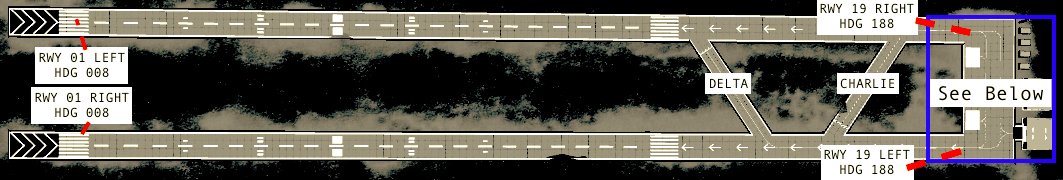
is something like this:
RWY 01 LEFT, 19 LEFT = Left pattern (LP)
RWY 01 RIGHT, 19 Right = Right pattern (RP)
(yeah there's a big mountain behind it, but when i get to Airport symbols you'll understand)
another airport that has both directions is Bandit Airport
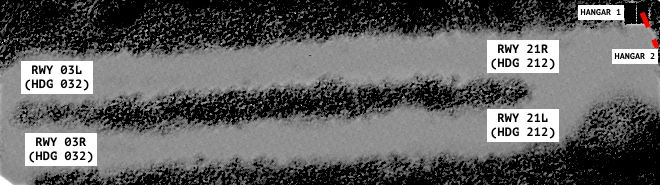
RWY 03L, 21L LP
RWY 03R, 21R RP
Bonus
14 CFR 31.113: Right of Way Rules (not for water aircraft operations)
-in general conditions just pay attention to what's going on around you, and who's around you doing what..
-these are rules to who has Right of way (usually in airport area).
the less power you have, you have the right of way from 1 to 10:
1-Aircraft in distress has right of way over everybody else!
2-Skydivers
3-Baloon
4-Glider
5-Airships and Towing or Refueling aircraft
6-powered parachute, Weight shift aircraft
7-Airplanes
8-Helicopters give everybody right of way because they can stop and land anywhere, and because they are the best!
-Two aircraft approaching each other Head-on: each aircraft should turn to the Right to avoid collision.
-Overtaking: the OVERTAKEN aircraft has right of way, the OVERTAKING aircraft should alter course to the right to pass well clear.
-When landing: The plane that is on Final Approach has right of way over all other aircraft.
if an aircraft is approaching Final, it may not be overtaken by cheeky pilots who want to be there first.
BONUS
You sometimes hear the phrase "Go Around".
This is a PROCEDURE in which you stop your decent, increase altitude and speed back to pattern altitude or to where the tower or regulations direct you.
This procedure can and should be made when you're not sure about your landing characteristics.
YOU CAN ALWAYS GO AROUND!
Bonus
Aircraft identification numbers or Tail numbers I.E. N895CL
these are essentially the aircraft registered license plate in aviation and what towers will call you as.
I will use N895CL for this example of US civil aviation number:
-N = the country of registration in this case N=USA
-895CL = number to identify, may only consist of one to five characters in total, and must start with a digit other than zero
-CL = Cleveland Ohio (city of registration) the last two letter are used sometimes to indicate a callsign (BT="blue thunder") or city of origin, or whatever you want as long as it's available."
Special Thanks to:
@KingHandspider for his post
check out my other posts:
Runway Numbers.... What How and why
Radio calls, how to Communicate as a Pilot in command.
Uncontrolled Simpleplanes Class G Communications... wait what?
I'm gonna start practicing this in SP and when possible on MP
Sorry for the wait, it was Holiday here (happy passover).
Hope you like it, let me know if I left something out :)
Feel free to share/use and ask about other things
Next time will be about ???
-write in the comments what you'd like :)
@MiladicPlanes you need to come on a steep bank for final for sure...
Or Just use 19L for Takeoff, and 01L for landing ;)
One question:
How do we make the final approach for Yeager's Runway 19L and 19R? There's the mountain which makes it impossible for a straight-in approach.
I'm thinking of a Kai Tak-like approach. Your opinion?
@XjayIndustrys Thank you :)
i luv dis
@Lahoski107
@JohnnyBoythePilot If I ever get to ship operations sure.
seaplanes follow Harbor/Sea rules and regulations once they are on the water. :)
@KingHandspider awesome :)
@Freerider2142 I may just use this information in a Airfield Charts and Data 2nd Edition ;)
Well done on this. I already know all of this info, but I do want to learn how to fly seaplanes on FSX this summer. If your up to the challenge, do a tutorial or introduction to floatplanes. If you do it tag me please. Thanks.
@KingHandspider ;)
@Mostly @Awsomur thanks :)
Wow, you’ve obviously done some research. Nice job.
nice
@Freerider2142 Haha, understood.
@Gestour i'll remember that for next time... or to when my hands are not cramped from typing...
It only works if you tag 3 people per comment.
@Mainblock @EternalDarkness @jamesPLNESii @ForeverPie @Stellarlabs @Alpha029 @Chancey21 @Marine @BaconAircraft @Airdude @Feanor @BrianAircraftsNew @Corsair013 @DemonSniper8 @Jetpackturtle @marcox43 @yoshicraze @Gestour @Strikefighter04 @MrSilverWolf @BoeyingOfficial @Rodrigo110 Razor3278 @Sgtk @weebabyseamus @MrDoolittle @KingHandspider , you guys upvoted you get the call ;)