
Wright Isles Regional Airport
JWAF
Geographical Data
Elevation above sea level: 232 ft (71 m)
Location: Wright Islands: Main Island
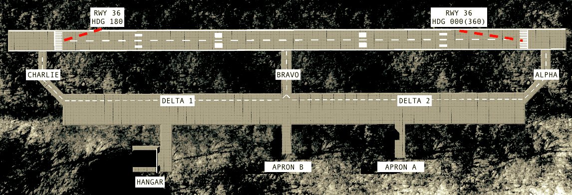
Airfield Data
Available Runways: 36/18 (000/180)
Available Hangars: 1 (L)
Available Aprons/Ramps: 2 Medium
Runway Lengths
36/18
Total Distance: 6336 ft (1931 m)
Available Distance: 5808 ft (1770 m)
Runway Obstructions
36: Unobstructed
18: Unobstructed
For the auxiliary airstrip located on the Wright North Island, see Wright Auxiliary North Airfield.
Yeager International Airport
JMRP
Geographical Data
Elevation above sea level: 1212 ft (370 m)
Location: Krackabloa: Murphy Island
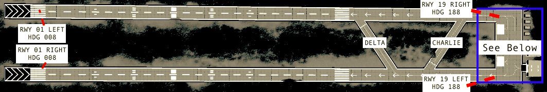
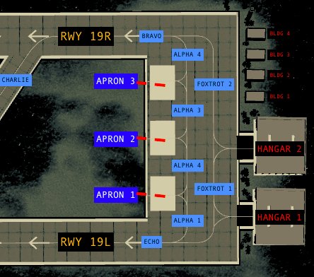
Airfield Data
Available Runways: 19L/01R; 19R/01L (189/009)
Available Hangars: 2 (L)
Available Aprons/Ramps: 3 Large
Runway Lengths
19L/01R
Total Distance: 8052 ft (2454 m)
Available Distance: 7920 ft (2414 m)
19R/01L
Total Distance: 8032 ft (2448 m)
Available Distance: 7900 ft (2407 m)
Runway Obstructions
19L/19R
Obstructed approach
Unobstructed departure
01L/01R
Obstructed departure
Unobstructed approach
This airport has formerly been known as Murphy Airport.
Avalanche CMR Airbase
SAVL
Geographical Data
Elevation above sea level: 202 ft (62 m)
Location: Snowstone Island
Distance from JWAF: 91.1 mi (146.6 km)
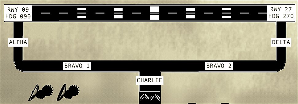
Airfield Data
Available Runways: 09/27 (090/270)
Available Aprons/Ramps: None
Available Hangars: 1 Large
Runway Lengths
09/27
Available Distance: Pending
Total Distance: Pending
Runway Obstructions
Unobstructed
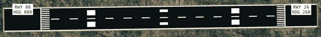
Wright Auxiliary North Airfield
JWNA
Geographical Data
Elevation above sea level: 907 ft (276 m)
Location: Wright Islands: North Island
Airfield Data
Available Runways: 08/26 (080/260)
Available Hangars: None
Available Aprons/Ramps: None
Runway Lengths
08/26
Total Distance: 3168 ft (965 m)
Available Distance: 3300 ft (1006 m)
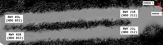
Bandit UISJ Army Airbase
BAAB
Geographical Data
Elevation above sea level: 612 ft (187 m)
Location: Krackabloa: Bandit(??) Island
Airfield Data
Available Runways: 21L/03R; 21R/03L (212/032)
Available Hangars: 2 (S)
Available Aprons/Ramps: None visible
Runway Lengths
21L/03R
Total Distance: 3846 ft (1172 m)
Available Distance: 3696 ft (1126 m)
21R/03L
Total Distance: 3762 ft (1146 m)
Available Distance: 3612 ft (1101 m)
Runway Obstructions
21L/21R
Unobstructed approach
Unobstructed departure
03L/03R
Unobstructed departure
Unobstructed approach
So usefull :)
EXCUSE ME? WRIGHT ISLES REGIONAL? IT IS WRIGHT CITY INTERNATIONAL AIRPORT
@Griffon1 raises weary head okay
@KingHandspider might want to update this for 1.11
u should probably add the fact that there are anti air threats at SAVL
I ment wright north airport but its longer now
I nearly have a plane as long as snowstone’s runway
thats explain why i always overrunning with the a380
since there is an plugin that made wright regional airport become intl airport so the name of the airport would be change if you have that plugin and use them any suggestions what the name would be
No problem! That’s cool! @KingHandspider
@Shnippy thenk you! I’m probably gonna re-do it soon
This is very neat
Runway 36 of Wright airport is easy to land
@airbusa380 the distance was measured by spawning an AI plane at one end of the runway, and being at the other. as for the 008-009 heading, its exactly in the middle of the two, so I rounded up. As for the Ice base, perhaps I’ll add it when I have more time :)
What about the army base (the one that shoots at you when you try to approach it) runway in Snowstone Valley?
P.S the Yeager runway is 008, not 009
Nice (I learnt a lot of things) How did you measure the distance?
@AZAMGAMING @8OxygeN8 @ZeroHours
@Freerider2142 Cool man! Yeah, this information is obviously free to use, just as long as you credit me. Which you are, so hooray!
Kind'a like this one
Hey man Great work!!
I'm making a few flight and airport information pages for the community, and I will totally be using this for examples (if you don't mind....)
I'll also post a link to this awesome page on my post and a link to your Profile :)
Again Great Work!!!
@jamesPLANESii no, no, its daring
I think having 2 runway 36s on Wright Airport is rather dangerous...
@marcox43 Thank you!
I've just taken a look at the Wright diagram, and both runway labels say RWY 36, and apparently Yeager has two 'Alpha 4' taxiways, but no 'Alpha 2'... WHOOPS
Very useful information!